
Powerful, hot and dry winds like those that have fanned the deadly wildfires now raging in California are a common occurrence in the state, a result of regional atmospheric patterns that develop in the fall.
The impact of climate change on the winds is uncertain, although some scientists think that global warming may at least be making the winds drier. “That is a pretty key parameter for fire risk,” said Alex Hall, a climate researcher at the University of California, Los Angeles.
The winds, known as Diablo winds in Northern California and Santa Ana winds further south, have their origin in the high desert of the Great Basin of Nevada and parts of Utah. High-pressure air that builds over that region flows toward lower-pressure air over California and the coast.
Along the way the air descends to lower elevations, which causes it to compress and become hotter and drier. The air picks up speed as it descends and funnels through canyons or across peaks that are lower than their neighbors.
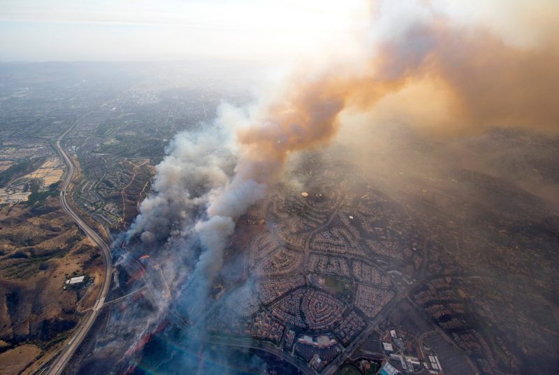
Click: Seen From Above: California Fires Reduced Entire Communities to Ash
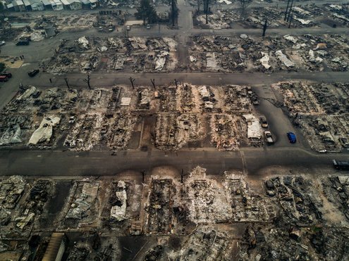
Click for the footage: Drone footage shows block after block of homes leveled by fire.
“The wind is seeking the path of least resistance to lower pressure,” Dr. Hall said. “That tends to be where there are gaps in the topography.”
The result is hot, dry winds with speeds that can exceed 70 miles per hour. In the wildfires that have devastated parts of Northern California’s wine country since Sunday night, the highest gusts were recorded in Sonoma County, at 79 m.p.h.
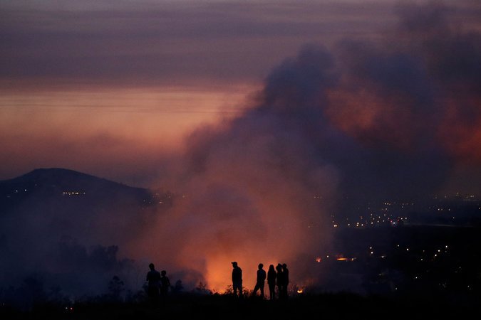
Fire on a hillside in Orange, Calif. Some scientists think global warming may be making autumn winds drier. Credit Jae C. Hong/Associated Press
The state got some respite from the winds on Tuesday, but they were expected to pick up again Wednesday and Thursday. Scientists said such variation is typical, as there is natural variability to large-scale climate patterns like high-pressure systems. If the high pressure over the Great Basin moves eastward, for example, the air will be less likely to flow westward, and that may allow cooler, gentler winds to move into California from offshore.
But there is also a day-night pattern to the winds. They tend to subside during daytime warmth, but as the land and atmosphere cool at night, the pressure gradient between the Great Basin air and California’s air increases. “The winds just pick up phenomenally,” said Norman Miller, an emeritus professor at the University of California, Berkeley.
Some of Dr. Miller’s research suggests that the high-wind season, which currently runs from about October to December or January, may lengthen as climate change continues. His climate simulations suggest that the warming atmosphere could lead to more high-pressure days in the Great Basin, and thus more days of strong winds.
But research by Dr. Hall and colleagues suggests that the frequency of high-wind events has been decreasing over several decades.
“The big picture to me seems to be that there’s conflicting evidence,” Dr. Hall said.
What seems clearer, he said, is that climate change may be making these strong winds drier. That’s because if the air over the desert of the Great Basin becomes warmer, its relative humidity will decrease. So as it descends into California it will become even drier.
“That’s likely to be a pretty robust feature of these events going forward,” Dr. Hall said.
By HENRY FOUNTAIN, The NYT
Follow @NYTClimate on Twitter
The 21st Century